Smap has been used for assessments since 2008. The same capabilities that make it a mature,
highly functional tool for DME or rapid assessments can also be used for management of a response,
including assisting the coordination of multiple agencies.
Relevant Features
Creation of forms using industry standard editors.
You can use forms interchangeably with other ODK
compatible servers.
Complete and submit forms using web browsers. Forms can be completed on laptops, iPads, iPhones,
Androids, in fact any device with a browser. The forms
can of course also be completed using fieldTask.
Collect location data including points, lines and polygons. Forms can include questions
such as “Show the boundaries of the area where aid
is being delivered today”; or “Show the path that was taken to reach the distribution point”.
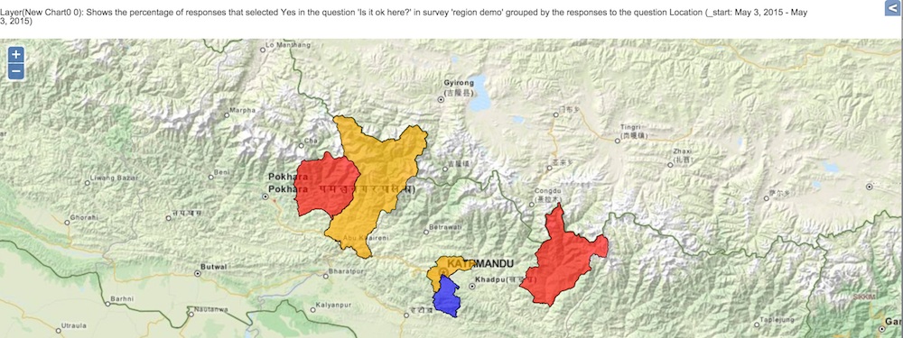
Powerful GIS capabilities. As soon as data is submitted it can be viewed
in the Smap dashboard and data with location can be shown on maps. The Smap Server
can be loaded with the boundaries of local regions so that the data
can be summarised by those regions. The picture at the heading of top of this page shows
data summarised by districts in Nepal.
Assign tasks to update a form. A person can be assigned a task to revise a
form that has previously been submitted and update the data. The form will be shown in their
browser, or fieldTask, showing the data they previously entered they can then modify and
re-submit.
Export data to other system for analysis. Data can be exported quickly and
easily to Excel, Stata or a GIS system for detailed analysis. This data can then be analysed
along with data from assessments to produce in depth reports and insights.
Multiple map backgrounds. The Humanitarian Openstreetmap
Team (HOT) create detailed maps of areas hit by emergencies. These can be shown as the background map in the
Smap dashboard along with Google satellite pictures and Google maps. Data collected in Smap can be
exported and loaded into the HOT server to contribute to the shared map.